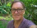
FunGIS Executive

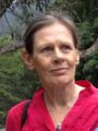
Melanie Stewart
Position: Chair
Mel is a Cairns local, born and educated in Far North Queensland. Studying environmental science at James Cook University, Mel was required to complete a course in GIS. What on Earth is GIS? Fast forward, 12 Years and Mel has worked in both state and federal government positions in GIS roles. Starting as a volunteer on the local tramp ant eradication programs was Mel’s“foot in the door”. She quickly became the team's swiss army knife, supervising field operations and working behind the scenes to support the programs with GIS. Switching over to the federal government in 2012, she has enjoyed the role of GIS officer for the Torres Strait Regional Authorities, Land and Sea Management Unit. The role brings with it a variety of mapping opportunities and challenges and Mel enjoys supporting communities and rangers working on country. When Mel isn’t mapping she is either running for enjoyment or chasing her children.
Anne Stapledon
Position: Appointed Secretary
I’m a teacher, community development worker and demographer and the focus of my work is empowerment, particularly for those who are disadvantaged.
I was introduced to GIS in 2001 by FunGIS life member Bob Peever and I’ve maintained my interest because of its potentials for:
- communicating demographic statistics at a glance;
- providing a means of empowerment for Indigenous people, particularly teenagers; and
- providing a potent tool for community development in rural/regional areas.
While I’m a spatial fringe dweller (ie. definitely not a teckie) I have a great deal of fun using GIS software (when Bob is able to lend me his laptop) and I particularly enjoy participating in the FunGIS network - grouse bunch of people.
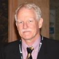
Hans Wurzel
Position: Deputy Chair
Hans has travelled far to land not far from home. He grew up on the Atherton Tablelands and attended school in Dimbulah and Mareeba. Before stretching further afield to study Environmental Science at JCU in Townsville. At uni Hans got a taste for GIS, which lead to work with the state and then local government. Alas after a while Hans got itchy feet and went visited his family in Germany, where he stayed for 18 months. On his return to Australia he decided do something completely different and joined the Navy. After nearly 7 years in the Navy and a calling to extend the family Hans called it quits. Luckily, he has come full circle to once again be working in the GIS field, this time for the state government in Cairns. He is currently working with Fisheries Queensland and is tasked with maintaining and updating key mapping layers. Hans also assists by preparing maps that aid in the assessment of development that could potentially impact on fisheries resources.
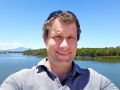
Tom Orr
Position: Treasurer
Tom attended Victoria University of Wellington, New Zealand where he gained a BSc in Zoology and a MSc in Geology. He has worked for more than 40 years as a geologist in Asia, Africa and Australia. These days he runs a small consultancy in Mission Beach together with his wife and fellow geologist Lisa. Most work revolves around the use of GIS which they have been using for more than 30 years. They have provided datasets to such organisations as the USGS, AGSO, BRGM, US National Hurricane Centre, and French Red Cross as well as numerous Universities and students. Tom is a keen sports photographer, drone pilot and gardener. Highlights of recent years include drone work for ABC Landline (his favourite TV show), nomination for Cairns Regional Council Volunteer of the year, being a Batonbearer for the Commonwealth Games Queen’s Baton Relay, building a Japanese Garden in his backyard and receiving the New Zealand Defence Force Service Medal.
Gary Searle
Position: Executive Committee Member
Gary is a Spatial Analyst and Town Planner who studied at James Cook University. Gary spent 7 years in Local Government on the Tablelands before joining Terrain NRM in 2013. Gary enjoys problem solving and finding ways to make and present maps that are meaningful and useful.

Tina Marton
Position: Executive Committee Member
Tina is a Cairns local with a background in biotechnology (genetics, biochemistry, microbiology), and speciality plant biotechnology techniques including plant tissue culture and cryopreservation. Through working in mineral exploration Tina was introduced to Geographical Information Systems. With a desire to improve her knowledge of GIS she studied an MSc majoring in Natural Resource Management (NRM). NRM introduced Tina to the challenges needed to be addressed for a sustainable future which have been coined Wicked Problems due to their multi-dimensional nature. Fundamentally Tina’s biotechnology degree shaped an innovative mind with a focus on simple solutions. She believes that geospatial tools are key to resolving many of the biggest challenges facing society. Tina has taken on an Executive Position with FunGIS, like others, to keep up to pace with the industry.
Neil Bryde
Position: Executive Committee Member
Neil is mostly retired somewhere in the hills and gullies of Herberton but occasionally
works in a small environmental consultancy firm. The geospatial aspect of this predominantly involves planning fieldwork transects and producing maps. For someone not involved every day in a geospatial working environment, being part of the FunGIS team is very rewarding.
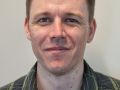
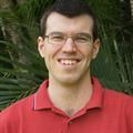
Dr. Matthew Harris
Position: Executive Committee Member
Matt moved to Cairns (and into GIS) in 2018 after completing his PhD in Archaeology at the University of Queensland in Brisbane. Matt’s PhD was his gateway into GIS - he used spatial analyses as part of his research into mollusc foraging and human engagement with coral reefs in the Marshall Islands. Soon after, he completed a Graduate Diploma of GIS and has been working as a GIS analyst for environmental and cultural heritage management firms since 2018. Matt has a broad range of experience including managing a team of GIS analysts, ArcGIS Enterprise development, cartography, spatial analysis, and technical illustration. The intersectional knowledge he has gained working in the private sector, his background in research, and his time as a technical illustrator have shown Matt the value that GIS can deliver to a range of stakeholders and clients. Outside of GIS, Matt is a keen bushwalker and can be found outside on the weekend getting to know his new home in the tropics a bit better.
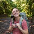
Amie Parker
Position: Executive Committee Member
I am a newbie in the GIS community and was only introduced to GIS in 2022 during my Masters in Global Change Biology at JCU. I was lucky enough to gain a position at Australian Spatial Analytics in Cairns and am now a lead data analyst working with a small team of neurodiverse individuals in spatial analytics projects.
I moved to Cairns in 2022 and have decided I could never live anywhere else. I am passionate about community and am excited to continue my GIS journey in FNQ.